Fukishima, Flint Michigan, Gulf of Mexico, Pacific Ocean fish die off, etc….and now….
Greatest Methane Release in History in CA and then this….coincidence?
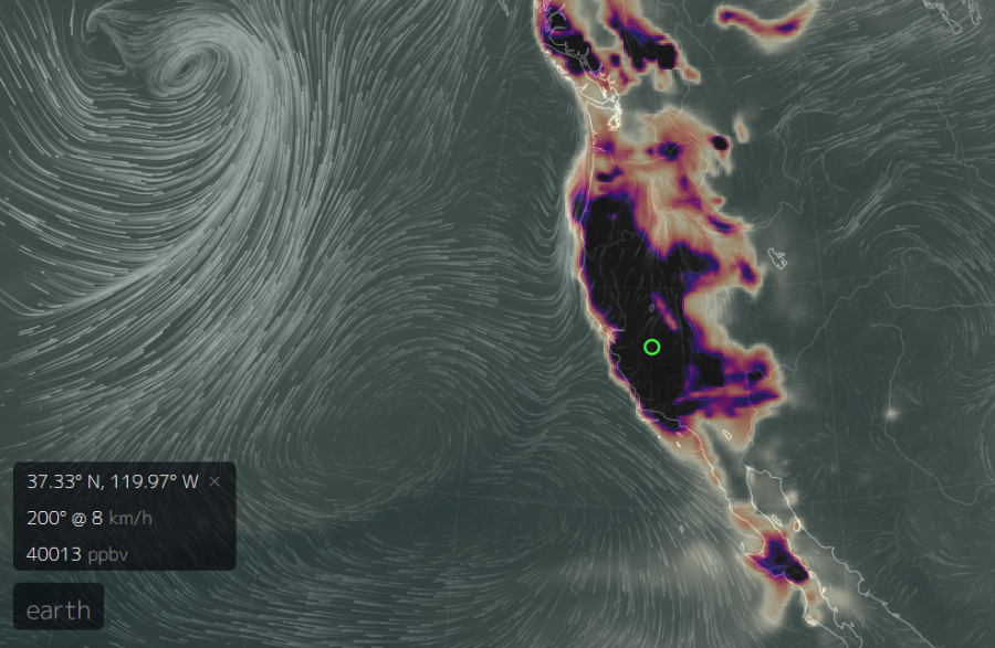
Carbon Monoxide Spikes to 40,000 Parts Per Billion over California on February 26
On February 26, The Global Forecast System model recorded an intense and wide-ranging carbon monoxide (CO) spike over the US West Coast. A region stretching from British Columbia, through Washington and Oregon, and on over most of California experienced CO readings ranging from about 5,000 parts per billion over the mountains of Southwestern Canada to as high as 40,000 parts per billion over Southern California. Very high peak readings appear to have occurred from Northern California near Eureka and along a line south and eastward over much of Central California to an extreme peak zone just north and west of Los Angeles near Palmdale.
For reference, these readings were between 25 and 200 times above typical background CO levels of about 200 parts per billion and up to twelve times higher than second highest peak readings over polluted regions of China during the same period.
Major Spike Appeared in Just 3 Hours Starting February 25th
****
65,000% Spike In Radiation Outside New York Nuclear Plant Is Likely Worse Than Fukushima
Buchanan, NY — An uncontrollable radioactive flow from the Indian Point nuclear power plant continues leaking into groundwater, which leads to the Hudson River, raising the specter of a Fukushima-like disaster only 25 miles from New York City.
The Indian Point nuclear plant is located on the Hudson River, approximately 25 miles North of NYC, and serves the electrical needs of an estimated 2 million people. Last month, while preparing a reactor for refueling, workers accidentally spilled some contaminated water, containing the radioactive hydrogen isotope tritium, causing a massive radiation spike in groundwater monitoring wells, with one well’s radioactivity increasing by as much as 65,000 percent.

Beckwith says the outgassing is indeed the faultline. No way a glitch. Stay safe brother.
LikeLike
…oops. If you haven’t seen it yet:
LikeLike
Nasa data unreliable (what a surprise):
http://gmao.gsfc.nasa.gov/news/geos_system_news/2016/incorrect_CO_concentrations.php
So by extension their arctic methane data must not be relied upon either.
LikeLike
nice catch. maybe the info is correct and Not a Space Agency doesn’t want the info out? who knows anymore.
LikeLike
But ESA, which I’m assuming collects their data independently from NASA, gets the same result, massive outgassing on the 26th. WTF?
http://macc.copernicus-atmosphere.eu/d/services/gac/nrt/nrt_fields!Carbon%20monoxide!Surface!18!Global!macc!od!enfo!nrt_fields!2016022600!!/
LikeLike
I don’t trust this one either. We KNOW their is mass methane releases going on in the Arctic, yet nothing is being shown on this map. My feeling is their is a central info release to all atmospheric reporting stations. Who the heck knows?
LikeLike
fwiw, NASA now says they had a malfunction which caused carbon monoxide measurements to be exaggerated….
http://www.dailykos.com/story/2016/2/29/1493107/–There-is-a-Major-Carbon-Monoxide-Explosion-on-the-West-Coast
and btw the european copernicus atmosphere monitoring program uses the same satellite – EOS-Terra…
https://atmosphere.copernicus.eu/cams-input-data
Of course that doesnt mean the west coast is not going to have an earthquake, because one day it will. Always be prepared for an emergency.
LikeLike